An unmanned Atlas V rocket carrying a classified payload for the National Reconnaissance Office blasted from Vandenberg Air Force Base at 7:19 p.m. Friday and lit the dark, cloudy sky.
Showing posts with label Spy satellites. Show all posts
Showing posts with label Spy satellites. Show all posts
December 16, 2014
Atlas V rocket launches defense satellite from Vandenberg Air Force Base
An unmanned Atlas V rocket carrying a classified payload for the National Reconnaissance Office blasted from Vandenberg Air Force Base at 7:19 p.m. Friday and lit the dark, cloudy sky.
September 17, 2014
Launch of Top Secret CLIO Payload on Atlas V Rocket
An Atlas V in the 401 configuration launched this morning, September 17th 2014 at 00:10 UTC carrying a top secret payload called CLIO. Little is known about this payload or even what agency will manage it, the satellite was constructed by Lockheed Martin. This was the 49th Alas V launch since 2002.
August 20, 2014
China's satellite images in public domain for first time
China launched high-definition Earth observation satellite into orbit - Gaofen-2. Photos shot with High-resolution multi-spectral camera technology.
Images of Lop Nur lake located between the Taklamakan and Kumtag deserts in the southeastern portion of Xinjiang Uygur Autonomous Region

Pictured Changji Hutubi Valley

Dongying estuary beach

Images of Lop Nur lake located between the Taklamakan and Kumtag deserts in the southeastern portion of Xinjiang Uygur Autonomous Region
Pictured Changji Hutubi Valley
Dongying estuary beach
April 28, 2014
Intel Community Backs High-Res Imagery Push

The White House is reviewing a proposal to lift the restriction preventing U.S. satellite imagery providers from releasing pictures with a resolution of less than 50 cm (19.7 in.). Adoption of the proposal to allow release of images with 25-cm resolution could kick off an explosion of global competition and products for satellite imagery providers hungry to expand substantially beyond the government market.
DigitalGlobe, the only remaining U.S. high-resolution satellite imagery provider, included the proposal in a licensing request filed last May. The first 50-cm license was provided in 2000. The company’s WorldView-3 satellite, capable of products with 31-cm resolution, is launching in August, and DigitalGlobe is worried its market share is being siphoned off by rival Airbus Defense and Space (formerly EADS Astrium) and others.
The U.S. intelligence community has “reached a consensus [that] bodes well for industry” supporting DigitalGlobe’s licensing request, Director of National Intelligence James Clapper said at last week’s 10th Annual Geoint conference here. National Reconnaissance Office Director Betty Sapp says she would rather focus her agency, which builds and operates U.S. spy satellites, on the most difficult, high-end challenges. “We want to make sure we are not doing anything they can do,” she says.
This harmony grew out of dissent. The intelligence community once had four different positions among three agencies, according to a government official. The White House is moving swiftly to come to a final government position and issue the license as soon as possible, this official says. However, there is still some discord among agencies outside the intelligence community. One option is to phase in the lower-resolution products, first allowing 31-cm imagery to accommodate WorldView’s capabilities and later 25-cm products.
http://aviationweek.com/space/intel-community-backs-high-res-imagery-push
April 27, 2014
Ukraine Crisis Scuttles Canadian Satellite Launch on Soyuz

Russia's actions in Ukraine have prompted the Canadian government to forego a planned launch of its M3M satellite atop a Soyuz rocket this summer, Canadian satellite manufacturer COM DEV International announced April 24.The satellite, a small maritime ship-tracking spacecraft, was previously scheduled to launch as a secondary payload on Soyuz from the Baikonur Cosmodrome, Kazakhstan, in June.
"Recognizing the current events in the Ukraine, we had been engaged in discussions with the Government of Canada with respect to a potential delay of the launch of M3M, and plans to mitigate the impact of any delay," said COM DEV CEO Mike Pley. "We are confident that the mitigations will be in place prior to the originally planned M3M in-service date of September 2014."
Built by COM DEV under contract to the Canadian Space Agency/Public Works Government Services Canada and the Department of National Defense, M3M is also subject to a commercial data sharing license with exactEarth, in which COM DEV is majority owner.
http://aviationweek.com/blog/ukraine-crisis-scuttles-canadian-satellite-launch-soyuz
April 21, 2014
Skybox Imaging HD Video of Burj Khalifa on April 9, 2014
Watch the plane fly at the bottom of the video.
April 20, 2014
Egyptian reconnaissance satellite (EgyptSat-2) launched by Russian Soyuz

A Russian Soyuz-U rocket was launched from Site 31/6 at the Baikonur Cosmodrome in Kazakhstan on Wednesday 16-04-2014. In what is expected to the last “non Progress” launch of this variant of Soyuz, an Egyptian spacecraft – known as EgyptSat-2 – enjoyed a ride uphill on the Russian workhorse. Launch occurred on schedule at 16:20 UTC.
The EgyptSat-2 satellite – which has seen its launch delayed several times – was built by RKK Energia and is destined for an operational orbit of 435 x 435 miles with a 51.6 degrees declination to the equator.The spacecraft follows on from the launch of EgyptSat-1, which was launched by a Dnepr rocket – a converted RS-20 intercontinental ballistic missile – in 2007. However, that satellite saw its life end in 2010, due to a failure of its S-Band communication system.
Weighing in at 1,050 kg, the Earth Observation satellite is being launched on behalf of Egypt’s National Authority for Remote Sensing and Space Sciences.The bird is equipped with three deployable, fixed solar arrays and X-band communications. It is expected to have an operational lifetime of 11 years, covering Egypt’s mapping, environmental monitoring and disaster management requirements.
April 13, 2014
US spy satellite - Atlas V NROL-67 Launch
United Launch Alliance (ULA) successfully launched the second mission in just seven days with the lift off of an Atlas V rocket carrying a payload for the National Reconnaissance Office. The mission lifted off from Space Launch Complex-41 on schedule on April 10 at 1:45 p.m. EDT. On April 3, ULA launched an Air Force weather satellite from Vandenberg Air Force Base, Calif.
April 10, 2014
First-of-its-kind U.S Secret - National Reconnaissance Office - Spy Satellite Ready for Launch

Read more on the story:
http://www.floridatoday.com/story/news/local/2014/04/10/atlas-v-secret-satellite-poised-launch/7535037/
Israel Launches OFEQ 10 Spy Satellite
 |
| A Shavit satellite launcher lifts off from the Palmachim test range south of Tel Aviv April 9, 2014, carrying the OFEQ 10 satellite, the eights satellite in the OFEQ family, built by IAI MBT Space division. Photo: IMOD |
The research and development department (MAFAT) of Israel’s Ministry of Defense in cooperation with Israel Aerospace Industries (IAI Ltd.) launched this evening Wednesday, April 9, 2014 at 22:15 hrs, “Ofeq 10″ (also known as Ofek 10) satellite into space. The satellite was launched into orbit by a “Shavit” satellite launcher. The launch was conducted from an Israeli Air Force test range.
Once the satellite enters orbit around the Earth, it will undergo several tests to confirm its serviceability and accurate performance.“Ofeq 10″ is an earth-observing remote-sensing satellite that employs synthetic aperture radar (SAR) technology with advanced “high-resolution” imagery, capable of operating day or night and in all weather conditions.
Israel’s Ministry of Defense, led by its R&D Department (MAFAT) in cooperation with Israel Aerospace Industries (IAI Ltd) and other Israeli high-tech companies developed and produced the “Ofeq 10″ satellite as well as the “Shavit” satellite launcher.
March 6, 2014
Looking Down From 600 km Above The Earth's Surface with HD Video
Watch the activity at North Korea's nuclear facility.
March 5, 2014
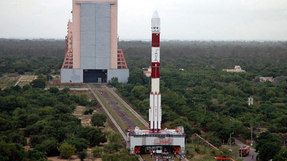
Indian Navy validates military satellite Rukmini or GSAT-7's network in Bay of Bengal during recently concluded Tropex Exercise
The exercise saw the western and eastern fleets amassing across the Bay for the intensive combat manoeuvres in all the three dimensions of “surface, air and underwater.
(China can take out satellites http://en.wikipedia.org/wiki/2007_Chinese_anti-satellite_missile_test)
ISRO photos via: www.isro.org


Indian navy used India’s first-ever dedicated military satellite, Rukmini or GSAT-7, to seamlessly network around 60 warships ,75 aircraft and unspecified number of submarines during a massive month-long naval combat exercise in the Bay of Bengal that ended last week.
The location of the exercise “Tropex,” or the theatre-level readiness and operational exercise, was significant since India is steadily bolstering military force-levels on the eastern coast and Andaman and Nicobar archipelago to counter China’s strategic moves in the critical Indian Ocean region (IOR).The geostationary naval communication and surveillance satellite, which has a 2,000-nautical mile footprint over the IOR, beams signals from its UHF, S, Ku and C-band transponders to network all warships and aircraft with operational centres ashore through high-speed encrypted data-links.Tropex exercises of the Indian navy provided with an opportunity to validate its network-centric warfare capabilities with the effective utilization of GSAT-7 satellite, which was launched last year.
Exercise Tropex (Theatre Level Readiness and Operational Exercise) involved combination of both the Eastern and the Western Fleets engaged in a month-long exercise.
(China can take out satellites http://en.wikipedia.org/wiki/2007_Chinese_anti-satellite_missile_test)
ISRO photos via: www.isro.org
 |
| Rukmini or GSAT-7 |
Indian navy used India’s first-ever dedicated military satellite, Rukmini or GSAT-7, to seamlessly network around 60 warships ,75 aircraft and unspecified number of submarines during a massive month-long naval combat exercise in the Bay of Bengal that ended last week.
The location of the exercise “Tropex,” or the theatre-level readiness and operational exercise, was significant since India is steadily bolstering military force-levels on the eastern coast and Andaman and Nicobar archipelago to counter China’s strategic moves in the critical Indian Ocean region (IOR).The geostationary naval communication and surveillance satellite, which has a 2,000-nautical mile footprint over the IOR, beams signals from its UHF, S, Ku and C-band transponders to network all warships and aircraft with operational centres ashore through high-speed encrypted data-links.Tropex exercises of the Indian navy provided with an opportunity to validate its network-centric warfare capabilities with the effective utilization of GSAT-7 satellite, which was launched last year.
 |
| TROPEX 2014 - Theatre Level Readiness and Operational Exercise |
Exercise Tropex (Theatre Level Readiness and Operational Exercise) involved combination of both the Eastern and the Western Fleets engaged in a month-long exercise.
June 4, 2012
First satellite for Indian Navy to be launched in a month
India venturing on a path of weaponize space and also working on Anti-Satellite weapons

NEW DELHI: The Indian Navy is finally set to get their first-ever dedicated military satellite, a naval surveillance and communications one, as part of their long-standing quest to effectively harness the final frontier of space. The geo-stationary naval satellite has "already been shipped out'' for its launch that will take place "within a month or so", government sources said.
A not-too-subtle indicator of the space event in the offing was also the creation of a new post of assistant chief of naval staff (communications, space and network-centric operations) at the Navy head-quarters over the weekend.Though tight-lipped about the "over-the-sea" satellite's launch, the Navy said a communications and electronic warfare specialist, had taken over as the new ACNS (CSNCO) in keeping with its endeavour to transform from a "platform-centric Navy'' to a "network-enabled Navy''.
The satellite, with an over 1,000 nautical mile footprint over the Indian Ocean Region (IOR) stretching from Africa's east coast right till Malacca Strait, will enable the Navy to network all its warships, submarines and aircraft with operational centres ashore through high-speed data-links.
There is an urgent need to keep real-time tabs over the rapidly-militarizing IOR, where China is increasingly expanding its strategic footprint, as well as on troop movements, missile silos, military installations and airbases across land borders.
The long-delayed naval satellite is to be followed by ones for the Army and IAF for "over-the-land use''. In absence of dedicated satellites, the armed forces have so far depended on "dual-use'' Indian satellites as well as lease of transponders on foreign ones for their navigation, communication, surveillance and reconnaissance purposes.
Subscribe to:
Posts (Atom)
